Section 9 – Torcross to Dartmouth
Start: Torcross car park. Grid ref: SX 82340 42280 what3words: potential.preheated.freshen
End: St Clements Church, Dartmouth Grid ref: SX 86930 51519 what3words: empires.searching.sideburns
Distance: 10.7 miles / 17.2 kilometres
Ascent / descent: (estimated) 1542ft/470m / 1184ft/361m
Difficulty: Strenuous
OS Map: Explorer OL20
Terrain: Coast path with steep ascents and descents, roads, fields, lanes, tracks
Parking: Torcross, Slapton Memorial, Strete Gate, Blackpool Sands, Little Dartmouth, Dartmouth Castle (limited), Dartmouth
Refreshments: Torcross, Strete Gate (seasonal), Strete village, Blackpool Sands (seasonal), Stoke Fleming, Dartmouth Castle, Dartmouth
Toilets: Strete Gate, Blackpool Sands, Stoke Fleming, Dartmouth Castle, Dartmouth
Public transport: Devon Public Transport Map
These directions are provided for guidance only. Weather, path closures and other factors may affect the route. Please take extra care when crossing roads and follow The Countryside Code at all times Download Countryside_Code_A5. All maps ©OpenStreetMap
This section is entirely on the South West Coast Path. Follow the acorn signs.
Much of the coastal fringe of South Devon is part of the South Devon National Landscape, formerly South Devon Area of Outstanding Natural Beauty.
Torcross to Little Dartmouth
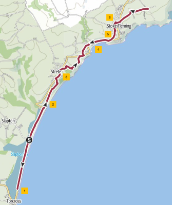
1. At the far end of Torcross car park, there is a public bird hide overlooking Slapton Ley lake, part of Slapton Ley Nature Reserve. Leave the car park and follow the path alongside the ley (lake) and parallel to the road. This is the 'Slapton Line' where the busy A379 road is built on a shingle ridge that separates the sea from the freshwater lake. After about 2 miles, cross the main road just before it turns left up a hill, and follow a lane between a wall on the left and the beach on the right. Proceed past a car park on the left and follow the coast path uphill.
2. When the path splits, take the right hand path. On your way up, be sure to look behind you at the magnificent view of Start Bay coastline with Slapton Ley in the foreground and Start Point Lighthouse in the distance. Continue steadily uphill, through the woods, to where the path meets the main road. Follow the path, which runs parallel to the road for 150yds. Walk along the main road for about 400yds through the village of Strete, passing a pub and shop/post office on the right.
3. After the bus stop on the right, go through a gate on the right onto the coast path again, then briefly onto a concrete track, then left to a footbridge. Follow coast path signs through gates and across fields. There are fine views along the coast eastward to the Daymark (see description later in text) above Kingswear and westward to Start Point Lighthouse. Descend steeply into a valley and up the other side to the main road again.
4. Cross the road, following the coast path signs to the right, and follow the edge of the field with the sea on your right. Near the corner of the field there is a single gate to the right that takes you into a wooded area. Follow the path round to the left to another gate. Turn left here and follow the edge of the field to the top of the hill where the path then bends right to another gate. Turn left at the gate onto a track and then immediately right onto another track. After about 100yds, turn right through a gate into a field. From here you will see views of Blackpool Sands in front of you. Follow the path downwards towards the bottom of the hill. Go through a gate into a small wooded area and down steps.
5. Where the path meets a lane coming from the left, with the main road on the right, cross the lane and go through a gate onto a footpath that goes over a footbridge; here the path runs parallel to the main road. At the next gate go straight across the main road to join a path on the other side. This is the entrance to Blackpool Sands.
6. From Blackpool Sands, pick up the coast path again which eventually joins a pavement alongside the main road. Continue uphill and, where the pavement ends, cross the main road and take the lane on the left. Follow the lane uphill, past St Peters Church on the right, and into the village of Stoke Fleming. Stoke Fleming At the crossroads turn right and head downhill, with the Green Dragon pub on your left. After 75yds turn right onto the main A379 coast road. The Village Shop is on the corner. After another 75yds, turn left down Shady Lane. Pass The Old Well Site on your left and continue along the lane; it eventually becomes a stony track. Turn left up a set of wooden steps and then follow the field edge uphill to join a lane. Turn right and walk along the lane for 0.5 mile to Little Dartmouth National Trust car park. Little Dartmouth.
Little Dartmouth to Dartmouth

1. From the car park at Little Dartmouth, go through a gate heading south-east towards the coast. Follow the signs for the coast path that leads along a gravel path. Look eastward and on the horizon there is a tall structure called a 'Daymark', built in 1864 as a navigational landmark for ships seeking the entrance to Dartmouth Harbour. At the end of the gravel path, at a gate, turn left, keeping a fence and then a wall on your left. After just under a mile, go through a gate where the path splits. Take the coast path downhill to the right to a fingerpost. You can detour to Compass Cove from here. Turn left and follow the coast path.
2. Follow the path through woodland. At the top of a hill, the path joins a lane from the left. Turn right and walk along the lane for about 10yds, then turn right down steps through woodland. When you come to a T-junction in the path at a bench, turn right. Follow the zigzag path down some steps passing above a small beach at Sugary Cove then climbing again to some benches above Sugary Green (where there are picnic tables).
3. At the junction with a lane from the left you will share some of the route with the Diamond Jubilee Way. Turn right and descend the steps to Dartmouth Castle. Dartmouth Castle In the summer months there is a ferry service from here to the town centre. Follow the coast path, parallel to the road, away from the castle, and in 0.5 mile turn right at a T junction onto Warfleet Road. The road leads into Dartmouth. As you descend a hill, there is a lookout point at Manor Gardens with splendid views. Now look for an entrance in the wall on your right down some steps to Bayards Cove Fort. From the fort, walk along Bayards Cove with its historic houses, popular with TV and film companies for period dramas. Bayard's Cove Fort
Discover Dartmouth – Things to do, places to stay in Dartmouth
Explore Dartmouth - Visitor Information for Dartmouth, Devon
4. Leaving Bayards Cove, pass the Dartmouth Lower Ferry terminal, and turn right into Coles Court following the road and turn left along the embankment. Dartmouth town centre has a wealth of shops, cafes, restaurants and hotels. You will reach the old harbour next to Royal Avenue Gardens with its historic bandstand. At the edge of the gardens and car park is Dartmouth Visitor Centre with its model of Thomas Newcomen's 'atmospheric' engine. Discover Dartmouth
Two ferries operate all year round, crossing the Dart river: the higher and lower ferries. Both carry vehicles and passengers. In addition, there are many other ferry services that take passengers across the river, upriver to Totnes (tide dependent) and down river to Dartmouth Castle. If you have time for a trip across the water, you could take a ride on the steam railway that runs from Kingswear to Paignton. Dartmouth Steam Railway
From the town you can see Britannia Royal Naval College, the magnificent building on a hill to the north, overlooking the town. It is the naval academy of the United Kingdom and the initial officer training establishment of the Royal Navy.
5. Exit the gardens, heading away from the river, into Duke Street. Dartmouth Museum is on the right. Turn first right into Foss Street. At the end of Foss Street go straight on up Brown’s Hill. At the top of the steps, turn left into Clarence Hill. At the top of the steps, turn left into Clarence Hill. At the top of the steps, turn left into Clarence Hill. Walk up Clarence Hill, which becomes Townstal Hill, then Mount Boone, then Church Road. Follow Church Road to St Clements Church on the left.
16 August 2025