Section 5 – Noss Mayo to Mothecombe
Start: Bridgend (end of Newton Creek), Noss Mayo SX 55556 48200 what3words: posts.palettes.cafe
End: Mothecombe slipway SX 61447 47618 what3words: sensual.less.states
Distance: 10.3 miles / 16.6 kilomtres
Ascent / descent: (estimated) 1352ft/412m / 1319ft/402m
Difficulty: Strenuous
OS Map: Explorer OL20
Terrain: Roads, footpaths, tracks, coast path with steep ascents and descents
Refreshments: Noss Mayo, Mothecombe
Parking: Noss Mayo tennis courts, National Trust Warren, National Trust Stoke Point, Mothecombe
Toilets: Noss Hard (Mar-Oct), Mothecombe
Public transport: Devon Public Transport Map
These directions are provided for guidance only. Weather, path closures and other factors may affect the route. Please take extra care when crossing roads and follow The Countryside Code at all times Download Countryside_Code_A5. All maps ©OpenStreetMap
This section is almost entirely on the South West Coast Path. Follow the acorn signs.
Bridgend to Stoke Down
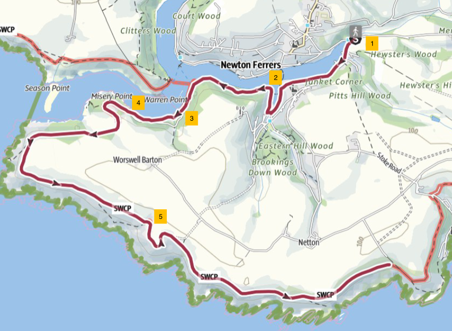
1. Starting at the head of Newton Creek at Bridgend, follow Stoke Road, keeping the creek on your right. Take the right hand fork at Junket Corner and head downhill. You will pass steps on your left that lead up to St Peter’s Church. Continue past The Swan Inn on the left. At the end of Creekside Road, the Newton and Noss Village Hall is in front of you. Turn right along Passage Road.
2. Walk along Passage Road, past The Ship Inn on your right. The road follows the side of the creek but after a short distance, a footpath runs above and parallel to the road. Use the path to avoid walking on the road. Soon Newton Creek meets the Yealm River. The parallel path rejoins the road just before a road junction.
3. In March 2025 the coast path route here was diverted due to a small landslip. Until the path is repaired (likely 2026) follow the signposted diversion and the South Hams Way signage, bearing left at the road junction and continue along the road until it becomes an unpaved track. The South Hams Way now follows the South West Coast Path as far as Dartmouth, 50 miles / 80 km away.
4. Continue along the track, past Battery Cottage and Coastguard Cottages, then go through a gate into National Trust The Warren. The path leads onto a headland with fine westerly views to Rame Head (Cornwall), the Mewstone and Saint Werburgh’s Church at Wembury. Follow the coast path above Gara Point and walk along Revelstoke Drive. On a clear day you can see Eddystone Lighthouse, 9 miles offshore to the south.
5. After Warren Cottage follow the path to a fingerpost; bear right signposted Stoke Beach 2m and follow the coast path for about 2 miles / 3 km until you reach a split in the path.
Stoke Down to Mothecombe
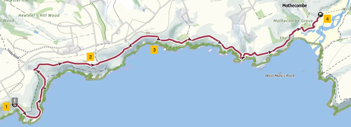
1. Straight on is the official coast path route – a higher path; if you take the right hand, lower path it will lead you to Revelstoke Park caravan park and Stoke Beach, past the ruins of the church of St Peter the Poor Fisherman. Turn slightly inland to rejoin the upper coast path at Stoke House. Turn right to continue on the coast path.
2. At Beacon Hill , where you can see the ruins of a tea house on the left, there is a choice of route. If you follow the coast path, the route is a very steep downhill. To avoid this, follow the alternative path to the left which leads to a road. Turn right onto the road and walk until you reach the next footpath turning on the right; this leads back to the coast. Turn left onto the coast path.
3. Follow the coast path eastward to Meadowsfoot Beach. Walk along the inland edge of the beach and then turn right along the coast path. After 0.3 mile / 0.5 km, a lane on the left leads to Mothecombe car park* where there is a café, but the main route continues along the coast path to the Old Coastguard Cottages.
4. At the slipway, for one hour either side of low tide only, you can wade across the River Erme to the Wonwell slipway on the east side of the river. Consult tide tables.
Mothecombe Beach tide times
Erme Estuary
*4 If the tide prevents wading across the Erme River, you could call a taxi from here to take you around to Wonwell - a distance of about 8 miles / 13 km. Sadly there is no suitable footpath (other than road walking) to avoid crossing the river. There is no ferry service.
16 August 2025