Section 6 - Wonwell to Hope Cove
Start: Bottom of slipway, Wonwell. Grid ref: SX 61980 47685 what3words: sensual.less.states
End: Old Lifeboat Station, Inner Hope, Hope Cove. Grid ref: SX 67509 39669 what 3 words: estimates.dining.online
Distance: 10.1 miles / 16.3 kilometres
Ascent / descent: (estimated) 1745ft/532m / 1759ft/536m
Difficulty: Strenuous
OS Map: Explorer OL20
Terrain: Coast path with steep ascents and descents, tracks, roads
Parking: Ayrmer Cove, Ringmore, Challaborough (very limited), Bigbury-on-Sea, Mount Folly, Bantham, Hoopers Dry (Thurlestone Sands), South Milton Sands
Refreshments: Challaborough (seasonal), Bigbury-on-Sea, Bantham (seasonal), South Milton Sands
Toilets: Challaborough (seasonal), Bigbury-on-Sea, Bantham, South Milton Sands
Public transport: Devon Public Transport Map
These directions are provided for guidance only. Weather, path closures and other factors may affect the route. Please take extra care when crossing roads and follow The Countryside Code at all times Download Countryside_Code_A5. All maps ©OpenStreetMap
This section is entirely on the South West Coast Path South West Coast Path. Follow the acorn signs.
Wonwell to Challaborough
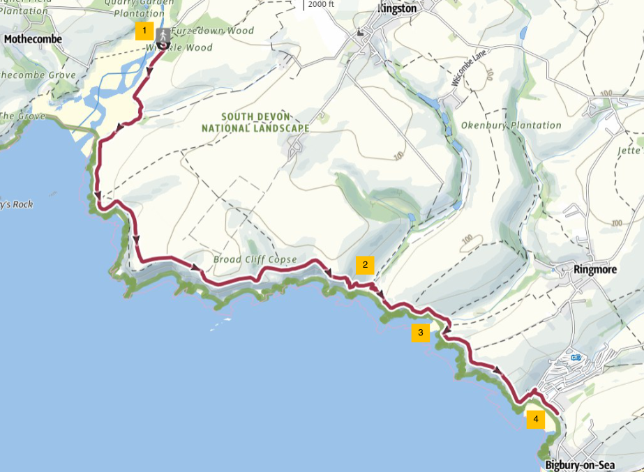
1. From Wonwell Beach, the village of Kingston is a short distance inland (1 mile / 1.6 km). Kingston Village. But to continue the South Hams Way, follow the coast path eastwards around Beacon Point to Westcombe Beach (1.6 miles / 2.6 km).
2. From Westcombe Beach there is another route inland to Kingston village. The South Hams Way continues along the coast path.
3. Continue along the coast path to Ayrmer Cove, where a path inland leads to Ringmore village (0.75 mile / 1.2 km). Ringmore Village.
4. Continue along the coast path from Ayrmer Cove to Challaborough (1 mile / 1.6 km). You will see Burgh Island ahead of you.
Challaborough to Hope Cove

1. Leave Challaborough Bay Holiday Park on the coast path, walking uphill on a track that joins a road to Bigbury-on-Sea. Follow the coast path into Bigbury-on-Sea village, to a large tarmacked car park.
From here you can enjoy the extensive sandy beach (dependent on tide) and Burgh Island with its iconic Art Deco hotel. At low tide you can walk across the sand to the island; when the sea submerges the sand, a ‘sea tractor’ operates, linking the mainland to the hotel and inn. The Sea Tractor | Burgh Island Hotel
2. At the far (eastern) end of the car park, take the coast path on the right down to a slipway where you turn left uphill. At the junction with the road, turn sharp right to follow the coast path around a small, grassy headland. When the path joins an access drive to houses, turn left downhill. Cross the road to join a footpath running parallel to the road (Folly Hill). At the top of the hill, turn right and cross the road again to Mount Folly Farm. Follow the coast path. There are panoramic views of the Avon Valley and Burgh Island from here.
3. Walk down the hill to Cockleridge Ham. Turn right to the ferry pickup point. The ferry is seasonal and operates from 1 April to 30 September (10-12am and 2-4pm daily). The ferry can be hailed from either side of the river.
When the ferry is not available, it is possible to walk inland on the west bank of the River Avon to Aveton Gifford and then to pick up the east bank to Bantham. Follow signs for the Avon Estuary Walk (8.8 miles / 14.2 km). Avon-Estuary-walk.pdf. Part of this route, going inland (north), is on a tidal road which requires a 1-mile diversion when the tide is high. On the Bigbury-on-Sea side, there is a short cut to the Avon Estuary Walk from a gate about 50yds/metres north of Mount Folly Farm entrance on the B3392. At the Bantham end, the Avon Estuary Walk is signposted from the top of the road down to Bantham slipway.
4. From Bantham Ferry point, follow the footpath up to a road and turn right into Bantham Car Park. Bantham Estate Follow the road past public toilets on the left and through the car park towards the beach, keeping the picnic area on your right. Take the coast path to the left of the Lifeguard Station. Follow the coast path around the edge of the field. There are fine views from here of Burgh Island and the mouth of the River Avon.
5. Continue along the coast path, keeping Thurlestone Golf Course on your left. Enjoy the fine views of Bolt Tail and Thurlestone Rock. Follow the path to where it joins a road and continue uphill past Thurlestone (Hoopers Dry) car park. Keep going along the coast path through a gate and across a footbridge. To your left is South Milton Ley Nature Reserve. Where the path meets the road turn right past toilets on the left towards a car park. South Milton Sands beach is on the right.
6. Walk south along a sandy track, with the National Trust car park on your left. Follow the track to where it joins a road and follow the road for about 150yds/metres. When the road bends sharply to the left, turn right and continue along the coast path. Look back at the spectacular coastal views of Burgh Island, Bantham Hand and Thurlestone Rock. Follow the coast path for about a mile to Hope Cove. Continue through the village, past public toilets on your right, until you reach the former Lifeboat Station. If you divert briefly here to your left, you will reach the picturesque village of Inner Hope with its thatched cottages.
30 May 2025