Section 1 - Totnes to Buckfastleigh
Start: Borough Park, Totnes, Grid ref SX 80370 60853, what3words: luxury.pesky.televise
End: Elliott Plain crossroads, Buckfastleigh, Grid ref SX 74215 66087, what3words: stepping.bookmark.grief
Distance: 7.1 miles / 11.4 Kilometres
Ascent / descent: (estimated): 617ft/188m / 548ft/167m
Difficulty: Moderate
OS Map: Explorer OL20 & OL28
Terrain: Footpaths, roads, woodland, tracks, country lanes, fields
Parking: Totnes, Dartington, Buckfastleigh
Refreshments: Totnes, Dartington, Buckfastleigh
Toilets: Totnes Railway Station, Dartington Visitor Centre, Staverton Station, Buckfastleigh
Public transport: Devon Public Transport Map
These directions are provided for guidance only. Weather, path closures and other factors may affect the route. Please take extra care when crossing roads and follow The Countryside Code at all times (Download Countryside_Code_A5.). All maps ©OpenStreetMap

1. Start the walk at the north-eastern corner of Borough Park, Totnes, by the children’s play area. Head north-west alongside the park on a tarmac path that leads to Totnes Railway Station car park. Turn right signposted Dartington 1¾ miles. At the river, turn left under the railway bridge. Bear immediately left at a junction in the path. To the right is a path and bridge leading to South Devon Steam Railway
Continue along the tarmac, multi-use path. Keep left where a dirt path heads to the right. Follow the path over a footbridge, then turn right. Continue for about 0.25 mile to a junction with Lower Drive to Dartington Estate. Turn right and go through the entrance gate to Dartington Estate, past Dartington Lodge on the left.
(If the Dartington Estate is not accessible for any reason – for example, forestry work may mean the woodland area is closed off for safety reasons – there is an alternative route that avoids the estate altogether. See end of these instructions for map)
2. Follow the road uphill for about 0.25 mile / 0.4km then turn right off the road onto a path leading down to the river. (Note: Stay on the road if there has been heavy rain as the riverside path can be very muddy. Both routes lead to the same place). Follow the path along the river and through woodland until you reach a gate and wall. Turn left away from the river along a fenced path and uphill to a gate. Proceed uphill and bear left where the path splits. At another gate, take the half left path uphill towards a gate leading onto a road opposite The White Hart sign. Turn right onto the road and walk to the Dartington Visitor Centre. Dartington Estate is a historic visitor destination incorporating Dartington Hall, Barn Cinema, cafes, The White Hart bar and restaurant, gardens, accommodation, campsite, shop and toilets. Dartington Estate
3. Turn right signposted Park Road / Warren Lane. Follow the road to Warren Lane. At the end of Warren Lane, go through a gate (to the left of the small car park) and head along a gravel track with woodland and a wall on your right. The deer park is also on your right; you may see fallow deer grazing in the fields or woodland. Continue straight on downhill for about 0.3 mile / 0.5km, following signposts for Long Trail. Where the signs for Long Trail indicate a right turn, keep straight on downhill and into woodland. This is North Wood.
4. Go straight on through the woods, keeping a field edge on your left. The path is narrow with tree roots underfoot. Keep straight on, past steps downward on the right and a marker post on the left, and then after about 50yds/metres, there is a split in the path. Keep left, slightly uphill. At the next split in the path, bear right downhill and follow the track through the woods. At the next junction, bear right downhill to a metal gate onto a lane.
5. From the North Wood exit gate, turn right and follow the lane across Staverton Bridge and the railway crossing. Turn immediately left, past South Devon Railway Staverton station. South Devon Railway. Here there is outdoor seating and toilets though opening hours may vary by season.
6. Walk along the lane for about 100yds/metres. At the first junction, fork right up a hill. Follow the lane for 0.75 mile / 1.2Km. After passing a footpath turning on the right, go over a bridge, then turn right onto a footpath after Orchard House. Go through two gates. Follow the footpath across a field to a metal gate and footbridge over a stream and then along the edge of another field with a stream on your left. At the end of the footpath turn left onto a lane.
7. Proceed along the lane, over a bridge. There is an old clapper (slab) bridge on the right. You may hear the hum of the electricity substation on the left as you walk along the road. After about 0.3 mile / 0.5Km, at the road junction at Bumpston Cross, turn right, signposted Landscove and Woolston Green. Nearby is Riverford Kitchen restaurant. Riverford Field Kitchen. Follow the lane for 0.3 mile / 0.5Km, then turn left onto a public footpath at Wash. Walk uphill along a track before joining a green lane that becomes a path that goes up a very uneven slope - rutted, muddy, watery and with tree roots - to a metal gate into a field. Follow the left hand field edge to a gate.
8. Turn right onto a wide uphill track. Continue 0.5 mile / 0.8Km along the track and past a travellers' site. At the end of the track join a lane and continue straight on for about 0.2 mile / 0.3Km, passing a left turning at Higher Beara Cross. Turn left into an access drive signposted Public Footpath and very soon take a left fork through two wooden gates onto a public footpath and into a field. From here there are good views of Buckfastleigh and distant Dartmoor.
9. Walk across the field, keeping a lone telegraph pole below and well to the right. Head downhill to a metal gate in a fence marking a woodland boundary. Go through the gate and follow the path through another gate and over a footbridge into the wood. Continue straight on to where another path crosses your way, following the public footpath sign straight on downhill through the wood. Traffic on the main road (A384) below can be heard from now on. The path is steep and may be slippery on the approach to the road so take extra care here.
10. At the bottom of the hill, before the road, turn right and walk along the woodland edge, on a path parallel to the road. The path emerges onto the main road opposite a bridge over the Dart River. Cross the main road here and proceed over the ancient Austin's Bridge, which dates from 1749. Then follow Old Totnes Road, firstly alongside the river, then over a railway bridge and along a residential road, for about 0.75 mile / 1.2Km into Buckfastleigh until you reach a junction with the B3380 at Elliott Plain crossroads.
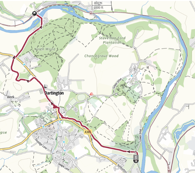
Alternative route, avoiding Dartington Estate. This route is accessible to cycles, mobility scooters, wheelchairs and pushchairs. If you take this route, pick up the route instructions from number 5 above.
19 May 2026