Section 3 – South Brent to Ivybridge
Start: Station Approach, South Brent. Grid REf: SX 69669 60365, what3words: registers.mingles.ballpoint
End: Ivybridge Library, Watermark Centre, Ivybridge. Grid Ref: SX 63639 516167, what3words: ears.crystal.trembles
Distance: 7.1 miles
Ascent / descent: (estimated) 971 / 1171 ft
Difficulty: Strenuous
OS Map: Explorer OL28
Terrain: Footpaths, tracks, bridleways, roads & moorland
Parking: South Brent,Ivybridge
Refreshments: South Brent, Ivybridge
Toilets: South Brent, Ivybridge
Public transport: Devon Public Transport Map
These directions are provided for guidance only. Weather, path closures and other factors may affect the route. Please take extra care when crossing roads and follow The Countryside Code at all times. All maps ©OpenStreetMap
Please follow the Responsible Walking on Dartmoor guide to reduce the impact of ground wear and erosion. Download Responsible Walking on Dartmoor guide.
South Brent to Ugborough Beacon
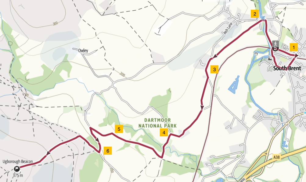
1. Walk along Station Approach and turn right over the railway bridge, along Hillside towards the centre of South Brent. The station closed in 1964 but mainline trains (London to Penzance) still use the line. The town offers plenty of facilities including shops, cafes, pubs and toilets. South Brent. Turn right at the T junction into Church Street. Follow the road around to the right, past St Petroc’s Church on the left. Take a footpath on your left, down a slope and under the railway, signposted Lydia Bridge. Follow an ancient shady walk of about 0.25 mile alongside the Avon River as far as Lydia Bridge. Climb up stone steps and over a stone stile onto a lane, and turn left onto the bridge.
2. Walk along the road to where it bends to the right. Here go straight ahead and cross a stile into a field, following the public footpath sign and Dartmoor Way towards Great Aish. (You will be sharing the route with the Dartmoor Way for about 1.3 miles The Dartmoor Way ). Ahead you can see Ugborough Beacon in the distance. Cross over wooden and stone stiles as you follow the footpath straight on through adjoining fields. The footpath continues slightly uphill over a field to a wooden gate. Here turn left onto a road.
3. Follow the lane for 250yds until you reach the next footpath sign on your right just after a house called Beechfield. A wooden stile leads into a field signposted Pennaton Lane. Cross another wooden stile into the next field and follow the footpath to a metal gate. Turn right onto a road. Continue along the road for about 0.5 mile until you reach a turning to the left signed “Unsuitable for motor vehicles”. Turn left down the hill.
4. Follow the lane down a hill to a moss-covered stone arch bridge over a stream (Glaze Brook). Walk over the bridge and continue until you reach a wooden gate on the right. A footpath sign shows the direction of Owley for the Moor . Go through the gate, keeping to the right of the two fields, at the bottom of a slope.
5. The footpath continues through a gap in the trees into the next field, and heads uphill to a wooden stile. Cross the stile and continue along the footpath, over a wooden footbridge and uphill through two wooden gates. After a third gate the path becomes a farm track leading uphill to another gate at a road where you turn left.
6. Follow the road uphill for about 350yds to a gate on the right leading onto the open moor. This is Peek Moor Gate. Walk through the gate and straight ahead, slightly uphill, keeping a stone wall on the right. When a fence on the left comes to an end, keep to the footpath for about 100yds until you see a red-topped marker post (easy to miss) on the left-hand slope (w3w catapult.cabbies.efficient; GR SX67528 59469). Turn left here and head steeply uphill. Continue climbing until you reach the granite outcrop of Ugborough Beacon. From here there are 360° views of open moorland to the north and the South Hams countryside to the south.
Note: there are no waymarkers on the open moor.
Ugborough Beacon to Ivybridge
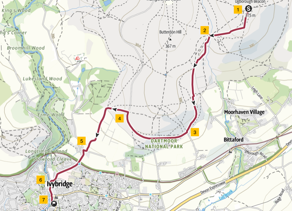
1. The highest point of Ugborough Beacon (378 metres) is a smaller clump of rocks slightly west of the main outcrop. From there turn left along a footpath heading directly south, away from the rock, at 90°. After about 120yds, the path splits (w3w flaking.convey.workroom; GR SX 66734 58982). Take the right-hand branch and follow it downhill. As you descend towards the valley below, you may catch sight of a glint of the Lud Brook. Head for the crossing point at Long Barrow .
2. Cross the Lud Brook and turn left downhill, keeping the stream roughly parallel. Where the path splits, bear left (w3w sentences.brush.glows; GR SX 66131 58586). About 100yds before a large gate ahead, take a path that branches right uphill to follow the outer perimeter wall of an area enclosing a neolithic, chambered tomb. This is Cuckoo Ball. Follow the wall for about 250yds and round a corner where it turns left and south. Very soon, the footpath splits; take the right-hand option, branching away from the wall. Continue downhill on the grassy path in a southerly direction. Below, on your left, is Moorhaven, now a large, prestigious housing development but originally an asylum, closed in 1992. Moorhaven Village
3. Follow the footpath straight on until you reach the Redlake Tramway – a wide track with a hard surface - completed in 1912 and used to transport men and materials by steam train to and from the clay works at Red Lake and the drying sheds at Cantrell. The total length of the track was eight miles and it ceased operation in 1932. You now share the path of the Dartmoor Way. The Dartmoor Way. Follow the tramway for about 0.75 mile, past an old quarry on the right. Look ahead to the white tops of the hills in the distance. These are the china clay works at Lee Moor, where the mine is still active. Also in sight now is the town of Ivybridge, your destination for this section of the South Hams Way.
4. When the tramway bends right, turn left in a westerly direction heading towards Stowford Moor Gate. Pass through the gate and continue downhill on a track with loose stones and rubble underfoot before arriving at a T junction. You are now sharing the route with the Two Moors Way.
5. Turn left into Harford Road. On your right is Stowford Farm. This road now curves to the right towards Stowford Bridge over the railway line which marks the boundary of the National Park. At the junction with Cole Lane, go straight across, continuing downhill on Harford Road. You will now pass Ivybridge Community College on your left, and around the corner on the right you will see the now defunct Stowford Paper Mill. There has been a mill on this site since the 17th century. It was rebuilt in 1862, ceased operation in 2013.
6. Continue along Harford Road which now levels out, with the River Erme on your right. Shortly you will see a small 16th century hump-backed bridge on the right; this is the ‘Ivy Bridge’ after which the town is named. Opposite the bridge, on the left, is a building, now converted to flats, which was the London Inn, a coaching inn on the route from Plymouth to Exeter and beyond. Continue along Harford Road with the a car park on your right. At the north end of the car park is a Venturi Water Pump that was used to power mills in the town. Also at the north end of the car park is the American Memorial commemorating the servicemen who were stationed in Ivybridge during WWII, many of whom lost their lives landing on Omaha Beach on D-Day.
7. At the T-junction, cross the road, and walk almost directly ahead of you into Costly Street. Shortly you will see The Watermark building on your left. The Watermark opened in 2008 as a community hub; it includes a public library, café, toilets, function rooms, cinema and offices. It is named after the special security paper produced at Stowford Paper Mill.
19 May 2026