Section 10 – Dartmouth to Totnes
Start: St Clements Church, Dartmouth Grid ref: SX 86930 51519 what3words: empires.searching.sideburns
End: Borough Park, Totnes. Grid Ref:SX 80370 60853 what3words: luxury.pesky.televise
Distance: 14 miles / 22.5 kilometres
Ascent / descent: (estimated) 1768ft/539m / 2096ft/639m
Difficulty: Strenuous
OS Map: Explorer OL20
Terrain: Roads, lanes, tracks, footpaths, fields
Parking: Dartmouth, Dittisham, Totnes
Refreshments: Dittisham, Cornworthy, Tuckenhay, Ashprington, Totnes
Toilets: Dittisham, Totnes
Public transport: Devon Public Transport Map Ferry Dartmouth to Totnes*
* Ferries from Dartmouth to Totnes Totnes Dartmouth River Cruise
These directions are provided for guidance only. Weather, path closures and other factors may affect the route. Please take extra care when crossing roads and follow The Countryside Code at all times.
Much of this section follows the same route the Dart Valley Trail and the John Musgrave Trail John Musgrave Heritage Trail
Dartmouth to Dittisham
 1. From St Clements Church, walk to the junction of Church Road and Townstal Road, the main A379. Cross the main road via a pedestrian refuge. Turn left uphill on the main road then right into Old Mill Lane. At the end of the road go straight across and down steps beside a turret and Archway Cottage. Soon you meet Old Mill Lane (again). Bear left and follow the lane downhill for 0.5 mile / 0.8 km to a stone bridge over the stream at the end of Old Mill Creek.
2. Cross the bridge and turn right, sign-posted Unmetalled Road. At the end of the tarmac road, bear left onto Lapthorne Lane, an unmade stony track. After 150yds/metres, turn right, through a kissing gate onto a footpath signposted Dittisham 2 ¾ miles. You are now entering the Raleigh Estate. Raleigh Estate Follow the footpath downhill through woodland. You may spot some Giant Sequoia (Redwood) trees alongside the path. There is a view, through trees, of Old Mill Creek and Hermitage Castle ruins on the opposite bank. Eventually climb a set of steep steps.
3. At the top of the steps, bear right through a metal stockproof gate. Continue uphill to where a fence ahead forces a left turn uphill. Follow the field edge and go through a single metal gate. Continue on the path, with the River Dart on your right, before turning sharply left to begin a long, steep ascent with a wire fence and a field on your left. At the top of hill there are views over the River Dart to Noss Marina. After a sharp right turn and steep down section, continue until you reach a wooden gate.
4. Turn left and walk uphill on a concreted farm track for about 250yds/metres. At the top of the hill, turn right onto a permissive path, keeping a fence and an open field on your left. Look behind you at views of the Britannia Royal Naval College, Kingswear, the Daymark and the open sea. On reaching a gate at the end of the field, turn right and follow the hedge on the right for about 80yds/metres before cutting left across the field towards an opening in the hedge on the opposite side.
5. Continue through a metal gate beside the hedge opening and go straight on along a farm track, keeping a hedge on your left. There are views on your right across the fields to Torquay and Torbay; to your left you will see Fire Beacon Hill and beyond that Dartmoor. On reaching a tarmac road, turn right, signposted Dittisham ¾ mile.
6. After about 150yds/metres, turn right through a gate onto a public footpath. Walk downhill along the lefthand side of a field and over a stile into another field. Keeping to the left, continue down and over another stile. From here there is a view, across the River Dart, of Greenway (Agatha Christie's summer residence, now owned by the National Trust). Continue down through the next field and through a wooden gate into another field, keeping the hedge on your left. Go over another stile at the end of this field and turn right onto a stony track.
7. Follow the track downhill. At a kissing gate, turn left along a lane into the village of Dittisham. At the end of this road, turn right into Manor Street then, after about 250yds/metres, turn left into The Lane. The lane becomes a footpath. Bear right at a fork and continue down alongside a stream on the right into an open grassy park area incorporating The Ham Playground. Walk along the left hand side of the park and toilets, and then turn immediately left onto a road.
8. Walk uphill to where this road joins Riverside Road. Turn left and continue up a gentle incline, passing St George’s Church on the right. At the road junction, signposted Coombe and Totnes, turn right and immediately right again down some steps. Join a road from the left and follow it downhill through the old village before climbing steeply uphill. At the junction at the top of the hill, turn right. Follow the road gently downhill until you are alongside Dittisham Mill Creek. Continue for about 0.4 mile / 0.6 km to the end of the creek where a footpath heads right over a stream.
Dittisham to Ashprington
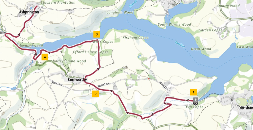
1. Turn right just before the Old Dittisham Mill , over a wooden foot bridge and then up some steep steps. Follow a path along a field by a wire fence. To your left you can see Brambletorre Mill, which has the largest water wheel in Devon. Walk on through a gate into a green lane until you meet a road. Turn left here, walk down and over a stone bridge, up a steep narrow hill and then right at Coombe Cross post. Walk on past Coombe Farm and Fingals to Barberry Cross. Go straight on here along a track and very shortly turn right down a green lane. Go up a steep and rocky hill for about 0.3 mile / 0.5 km, passing Higher Broadgates Farm where the track becomes a road.
2. Walk along the road to the crossroads at Longland Cross. Go straight over and down the hill, turning right at the end into the village of Cornworthy. The Church will be on your right. The tower of St Peter’s Church, Cornworthy has three layers - one upon another, a style unique to Devon. The church features a beautiful roodscreen, Georgian pulpit and Norman font. Walk past the church, keeping the village hall on your right, and go straight ahead through an entrance into Cornworthy Court. Follow footpath signs through the farmyard and on down a track which then bends left. Follow the track downhill. Walk along the edge of a field, down to Bow Creek.
3. Turn left and walk along the bank, through a gate and onto the foreshore. Bow Creek is rich in birdlife including herons, swans, egrets and kingfishers as well as a variety of gulls, ducks and Canada geese. After 150yds/metres turn left onto a path that goes up and down alongside the creek through fields and woodland. After a footbridge and stile, turn right signposted Tuckenhay ½. After 100yds/metres, turn left up steps to join a gravel path. Follow this for 150yds/metres then take the right fork in the path leading to an information board. Bow Wood , above you here on the slopes, was planted with 13,500 trees and shrubs on 30 acres of steep and muddy land in 2019 and is now a haven for wildlife where trees are thriving through natural regeneration.
Tuckenhay was home to a paper mill that once made high quality paper for artists and for making bank notes. It also had a cider factory, lime kilns and bustling quays.
4. After a gate, turn left up steps to a path with blue rope fencing through woodland alongside the creek. Continue until you reach a metal stile. Turn right onto a road, and then right again. Walk along the road for about 0.5 mile / 0.8 km, passing two public houses. Turn right over a bridge and right again towards Ashprington. Walk uphill on the road for another 0.5 mile / 0.8 km into Ashprington village. Go past the war memorial, keeping a public house on your right and the church on your left.
Ashprington developed as an estate village for Sharpham House and many of the houses have similar architecture with diamond-shaped window panes. The Durant Arms was named after Richard Durant, the 19th Century Squire, renowned for fining his tenants for using bad language. The village has the 14th century Church of St David with a beautiful lych-gate entrance.
Ashprington to Borough Park, Totnes
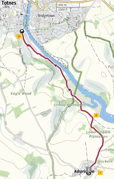
1. From the church in Ashprington, leave the village along an uphill lane heading north-east. After about 250yds/metres, at the large Sharpham sign on the right, take the pedestrian path parallel to the road. Cross the road at the end of the path, ignoring the road into Sharpham Estate. After passing through an area of woodland on the track, climb over a stile on the right taking you down towards the river through a field. On a promontory to the right is Sharpham House and its 550 acre estate. The estate includes a Heritage Trail describing places of interest along the route (see map on website). Sharpham Trust
2. Turn left onto a track which joins from the right and follow this parallel to the river. When you join a tarmac path, follow it straight on uphill for about 350yds/metres then turn right downhill through a grassy area towards the river again. (From here, if there has been a lot of rain, the suggested path may become muddy; you can continue along the tarmac route - National Cycle Path 28 - to Totnes, a dryer, higher route). Continue along this path for about a mile. At the top of a zigzag uphill stretch, join a lane (Sharpham Drive) and follow this to a T-junction.
3. At the end of Sharpham Drive, turn right, then immediately left into New Walk. After about 10yds/metres turn right onto a public footpath and at the end of the path turn right and continue along the road to a roundabout. Here a stone obelisk commemorates William Wills, explorer of Australia, born in Totnes in 1834. The British surveyor and surgeon was second-in-command of the Burke and Wills expedition, an ill-fated attempt to cross Australia from south to north. This is also the start of the 7-mile / 11 km Franklin Trail - a circular tour of Totnes.
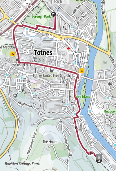
4. Turn left into Fore Street with its many shops, cafes and restaurants, and walk up the hill, under the archway, past St Mary's Church on your right, and past the Market Square on your left. The road is now called High Street. Turn right off High Street into Castle Street. Totnes Castle (English Heritage) is on your left. Totnes Castle. Follow Castle Street under an archway, then take a footpath to the left of Northgate Lodge. The footpath rejoins Castle Street further on down the hill.
5. Carry on along Castle Street until it meets the A385, Station Road. Cross the road at the pedestrian crossing and turn right. Walk for about 100yds/metres before taking the first left into a short access road leading to Borough Park. Turn right and follow the footpath along the edge of the park to a road. Turn left and pass Totnes Leisure Centre and a children’s play park. This is the end of Section 10 – the final section - of the South Hams Way. Totnes Railway Station is next to the park.
South Devon Railway steam train station is nearby; heritage trains run from here to Buckfastleigh via Staverton. Follow the signposts from Totnes Station car park. South Devon Railway
16 August 2025