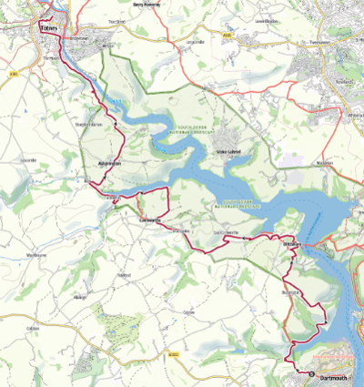
The sections
The full route - all 10 sections
101 miles in 10 sections:
1/ Totnes to Buckfastleigh 7.1m / 11.4km
2/ Buckfastleigh to South Brent 8.9m / 14.3 km
3/ South Brent to Ivybridge 7.1m / 11.4 km
4/ Ivybridge to Noss Mayo 11.9m / 19.2 km
5/ Noss Mayo to Mothecombe 10.3m / 16.6 km
6/ Wonwell to Hope Cove 10.1m / 16.3 km
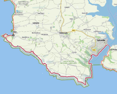
7/ Hope Cove to Salcombe 8.1m / 13 km
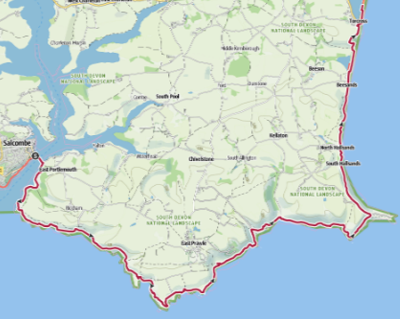
8/ East Portlemouth to Torcross 13m / 21 km
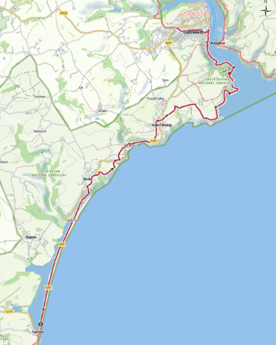
9/ Torcross to Dartmouth 10.7m / 17.2 km
10/ Dartmouth to Totnes 14m / 22.5 km
GPX of the entire route: Download South Hams Way GPX

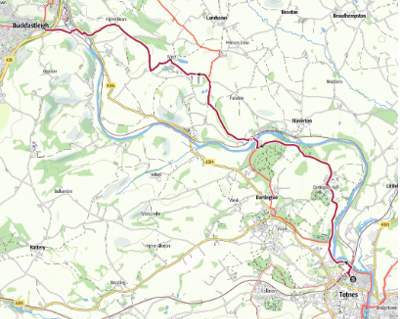
Section 1 - Totnes to Buckfastleigh
Start: Borough Park, Totnes. Grid ref SX 80370 60853, what3words: luxury.pesky.televise
End: Elliott Plain crossroads, Buckfastleigh. Grid ref SX 74215 66087, what3words: stepping.bookmark.grief
Distance: 7.1 miles / 11.4 Kilometers
Ascent / descent (estimated): 617ft/188m / 548ft/167m
Difficulty: Moderate
OS Map: Explorer OL20 & OL28
Terrain: Footpaths, roads, woodland, tracks, country lanes, fields
Parking: Totnes, Dartington, Buckfastleigh
Refreshments: Totnes, Dartington, Staverton, Buckfastleigh
Toilets: Totnes Railway Station, Dartington Visitor Centre, Staverton Station, Buckfastleigh.
The Route Map: Download Section 1 map
Route Guide: Download Section 1 guide
Route GPX: Download Section 1 GPX
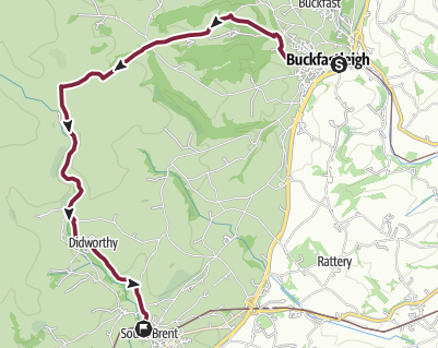
Section 2 – Buckfastleigh to South Brent
Start: Elliott Plain crossroads, Buckfastleigh. Grid ref: SX 74215 66087 what3words: stepping.bookmark.grief
End: Station Approach, South Brent. Grid ref: SX 69669 60365 what3words: registers.mingles.ballpoint
Distance: 8.9 miles / 14.3 kilometres
Ascent / descent: (estimated) 1175ft/358m / 876ft/267m
Difficulty: Strenuous
OS Map: Explorer OL28
Terrain: roads, woodland, tracks, footpaths, fields, moorland
Parking: Buckfastleigh, Shipley Bridge, South Brent
Refreshments: Buckfastleigh, Shipley Bridge – seasonal, South Brent
Toilets: Buckfastleigh, Shipley Bridge, South Brent
The Route Map: Download Section 2 map
Route Guide: Download Section 2 guide
Route GPX: Download Section 2 GPX
Responsible walking on Dartmoor: Download Responsible Walking
Temporary closure of path: Download Avon Reservoir to South Brent diversion
Section 3 – South Brent to Ivybridge
Start: Station Approach, South Brent. Grid ref: SX 69669 60365 what3words: registers.mingles.ballpoint
End: Ivybridge Library, Watermark Centre, Ivybridge. Grid Ref: SX 63639 516167, what3words: ears.crystal.trembles
Distance: 7.1 miles / 11.4 kilometres
Ascent / descent: (estimated) 971ft/296m / 1171ft/357m
Difficulty: Moderate
OS Map: Explorer OL28
Terrain: Footpaths, tracks, bridleways, tarmac roads & moorland
Parking: South Brent,Ivybridge
Refreshments: South Brent, Ivybridge
Toilets: South Brent, Ivybridge
The Route Map: Download Section 3 map
Route Guide: Download Section 3 guide
Route GPX: Download Section 3 GPX
Responsible walking on Dartmoor: Download Responsible Walking

Section 4 - Ivybridge to Noss Mayo
Start: Ivybridge Library, Watermark Centre, Ivybridge. Grid Ref: SX 63639 516167, what3words: ears.crystal.trembles
End: Bridgend (end of Newton Creek), Noss Mayo. Grid ref: SX 55556 48200 what3words: posts.palettes.cafe
Distance: 11.9 miles / 19.2 kilomeres
Ascent / descent: (estimated) 991ft/302m / 1178ft/359m
Difficulty: Moderate
OS Map: Explorer OL20
Terrain: Footpaths, fields, roads, country lanes, gravel tracks, woodland
Parking: Ivybridge, Ermington (limited), Yealmpton, Noss Mayo
Refreshments: Ivybridge, Ermington, Yealmpton, Noss Mayo
Toilets: Ivybridge, Ermington, Noss Mayo
The Route Map: Download Section 4 map
Route Guide: Download Section 4 guide
Route GPX: Download Section_4_GPX

Section 5 – Noss Mayo to Mothecombe
Start: Bridgend (end of Newton Creek), Noss Mayo. Grid ref: SX 55556 48200 what3words: posts.palettes.cafe
End: Mothecombe slipway. Grid ref: SX 61447 47618 what3words: sensual.less.states
Distance: 10.3 miles / 16.6 kilometres
Ascent / descent: (estimated) 1352ft/412m / 1319ft/402m
Difficulty: Strenuous
OS Map: Explorer OL20
Terrain: Roads, footpaths, tracks, coast path with steep ascents and descents
Refreshments: Noss Mayo, Mothecombe
Parking: Noss Mayo tennis courts, National Trust Warren, National Trust Stoke Point, Mothecombe
Toilets: Noss Hard (Mar-Oct), Mothecombe
Public transport: Devon Public Transport Map
The Route Map: Download Section 5 map
Route Guide: Download Section 5 guide
Route GPX: Download Section 5 GPX

Section 6 - Wonwell to Hope Cove
Start: Bottom of slipway, Wonwell. Grid ref: SX 61980 47685 what3words: sensual.less.states
End: Old Lifeboat Station, Inner Hope, Hope Cove. Grid ref: SX 67509 39669 what 3 words: estimates.dining.online
Distance: 10.1 miles / 16.3 kilometres
Ascent / descent: (estimated) 1745ft/532m / 1759ft/536m
Difficulty: Strenuous
OS Map: Explorer OL20
Terrain: Coast path with steep ascents and descents, tracks, roads
Parking: Ayrmer Cove, Ringmore, Challaborough (very limited), Bigbury-on-Sea, Mount Folly, Bantham, Hoopers Dry (Thurlestone Sands), South Milton Sands
Refreshments: Challaborough (seasonal), Bigbury-on-Sea, Bantham (seasonal), South Milton Sands
Toilets: Challaborough (seasonal), Bigbury-on-Sea, Bantham, South Milton Sands
The Route Map: Download Section 6 map
Route Guide: Download Section 6 guide
Route GPX: Download Section 6 GPX

Section 7 – Hope Cove to Salcombe
Start: Old Lifeboat Station, Inner Hope, Hope Cove. Grid ref: SX 67509 39669 what 3 words: estimates.dining.online
End: Ferry point, Salcombe. Grid ref: SX 74145 38864 what3words: gain.curving.breakaway
Distance: 8.1 miles
Ascent / descent: (estimated) 1056 / 1050 ft
Difficulty: Strenuous
OS Map: Explorer OL20
Terrain: Coast path with some steep ascents and descents, woodland, gravel tracks, lanes and roads
Parking: Hope Cove, Bolberry Down, East Soar, Overbecks (Salcombe), North Sands (Salcombe), Shadycombe Road (Salcombe)
Refreshments: Hope Cove, Bolberry Down, Overbecks (Salcombe)- seasonal, South Sands (Salcombe), North Sands (Salcombe), Salcombe
Toilets: Hope Cove, South Sands (Salcombe), North Sands (Salcombe), Whitestrand (Salcombe)
The Route Map: Download Section 7 map
Route Guide: Download Section 7 guide
Route GPX: Download Section 7 GPX
Section 8 – East Portlemouth to Torcross
Start: East Portlemouth ferry point. Grid ref: SX 74326 38692 what3words: dugouts.owls.sprinkle
End: Torcross Tank car park. Grid ref: SX 82341 42280 what3words: blanking.outlooks.badge
Distance: 13 miles / 21 kilometres
Ascent / descent: (estimated) 1798ft/548m / 1824ft/556m
Difficulty: Strenuous
OS Map: Explorer OL20
Terrain: Roads, coast path (rocky, narrow & precipitous in places)
Parking: Mill Bay, Gara Rock Hotel, Prawle Point, Start Point, Torcross
Refreshments: East Portlemouth (seasonal), Gara Rock Hotel, Beesands, Torcross
Toilets: Mill Bay, Start Point (seasonal), Beesands, Torcross
The Route Map: Download Section 8 map
Route Guide: Download Section 8 guide
Route GPX: Download Section 8 GPX
Section 9 – Torcross to Dartmouth
Start: Torcross car park. Grid ref: SX 82340 42280 what3words: potential.preheated.freshen
End: St Clements Church, Dartmouth Grid ref: SX 86930 51519 what3words: empires.searching.sideburns
Distance: 10.7 miles / 17.2 kilometres
Ascent / descent: (estimated) 1542ft/470m / 1184ft/361m
Difficulty: Strenuous
OS Map: Explorer OL20
Terrain: Coast path with steep ascents and descents, roads, fields, lanes, tracks
Parking: Torcross, Slapton Memorial, Strete Gate, Blackpool Sands, Little Dartmouth, Dartmouth Castle (limited), Dartmouth
Refreshments: Torcross, Strete Gate (seasonal), Strete village, Blackpool Sands (seasonal), Stoke Fleming, Dartmouth Castle, Dartmouth
Toilets: Strete Gate, Blackpool Sands, Stoke Fleming, Dartmouth Castle, Dartmouth
The Route Map: Download Section 9 map
Route Guide: Download Section 9 guide
Route GPX: Download Section 9 GPX
Section 10 – Dartmouth to Totnes
Start: St Clements Church, Dartmouth Grid ref: SX 86930 51519 what3words: empires.searching.sideburns
End: Borough Park, Totnes. Grid Ref:SX 80370 60853 what3words: luxury.pesky.televise
Distance: 14 miles / 22.5 kilometres
Ascent / descent: (estimated) 1768ft/539m / 2096ft/639m
Difficulty: Strenuous
OS Map: Explorer OL20
Terrain: Roads, lanes, tracks, footpaths, fields
Parking: Dartmouth, Dittisham, Totnes
Refreshments: Dittisham, Cornworthy, Tuckenhay, Ashprington, Totnes
Toilets: Dittisham, Totnes
The Route Map: Download Section 10 map
Route Guide: Download Section 10 guide
Route GPX: Download Section 10 GPX