About the trail
The South Hams Way is a self-guided trail created by the South Hams Ramblers, a group within The Ramblers Association, a registered charity (England & Wales no. 1093577, Scotland no. SC039799).
This website, including trail information, route guides, maps and GPX files, has been created by walkers for walkers. Route guides may be reproduced for personal use only for the purpose of walking the trail.
Commercial Use
We encourage businesses in the tourism sector to take advantage of the trail in their marketing and as an option in their commercial offerings. If the trail brings you income then please consider making a donation to help us maintain and promote the trail.
Copyright: Copyright conditions apply to what can be reproduced from this website - please contact the webmaster for details.
Accommodation
We do not advertise or recommend accommodation. As a premier tourist destination there is considerable choice offered along the trail. Try the websites of Visit South Devon at Where to Stay. Also search on social media with #southhamsway and #thesouthhamsway for recommendations by those who have walked the trail.
Using this website
1/ The Sections Preview page lists each section with its primary information together with the following downloadable documents.:
- A printable pdf map of the section route.
- A printable pdf of the Route Guides summarising key elements and describing the route in anti-clockwise direction. Guides can be updated as required. To ensure you have the latest version then download nearer your time of travel.
- A route GPX for Navigation Apps.
2/ All 10 Sections route guides are also available as online web pages which can be followed on a mobile phone.
3/ Footpath updates and closures: routes regularly need updating and closures can be at short notice. Always check this website and download the information for your chosen section closer to your date of departure.
Follow the waymarkers
The route follows existing public footpaths, bridleways and lanes signposted by the Public Footpath waymarker. Look out also for the occasional South Hams Way waymarker to make sure you are on the right track. There are no waymarkers on open moorland of Dartmoor National Park. On the South West Coast Path there is minimal South Hams Way signage so follow the acorn signs. 
Ten sections
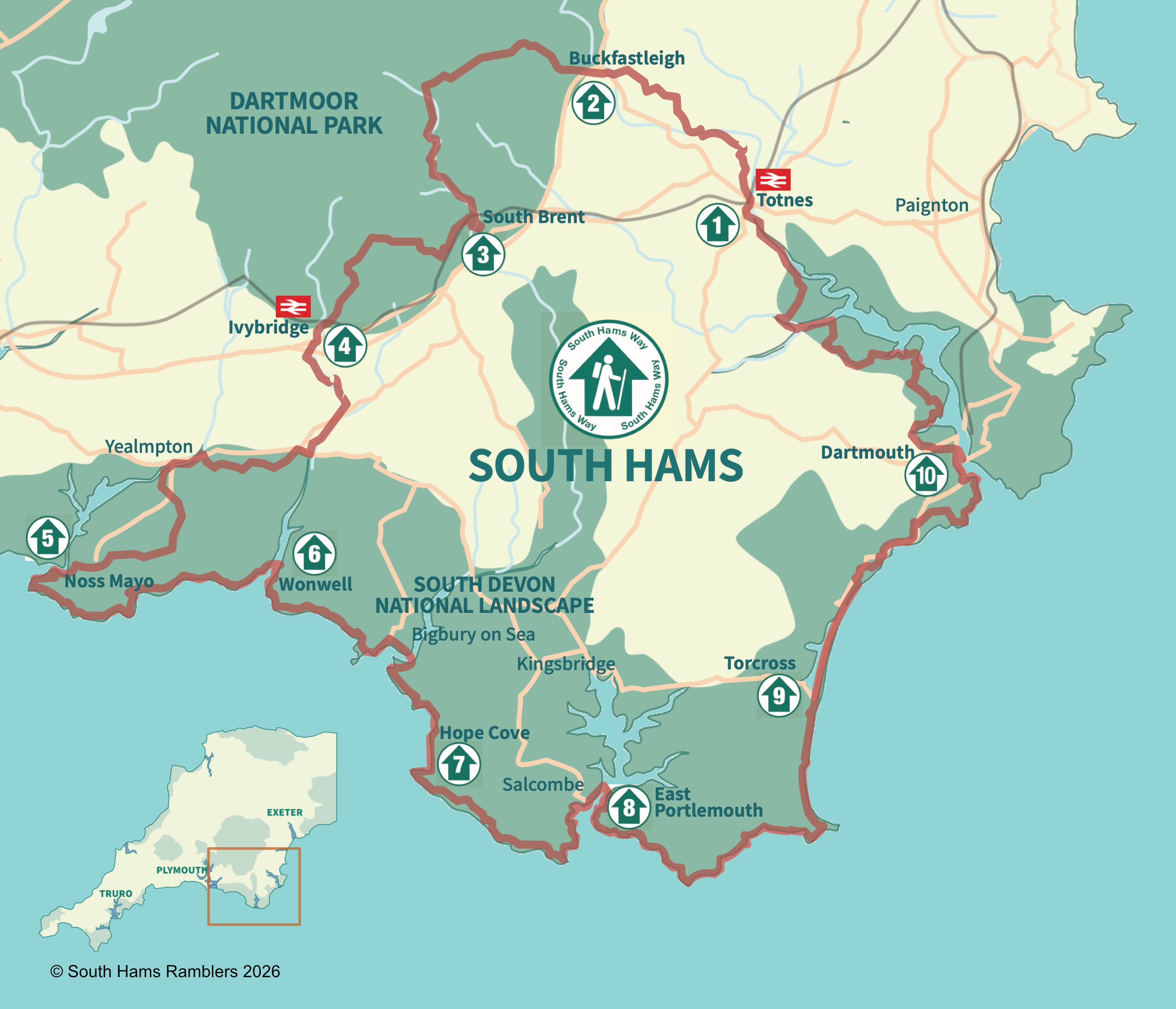
The gateway to the trail is Totnes. The route is divided into ten sections of roughly 10 miles each. The sections are deliberately centered on community hubs where there is public transport access, shops, refreshments and accommodation.
Which direction?
Although the South Hams Way is described in an anti-clockwise direction it can be tackled in any direction, from any point. In parts, it shares its route with other established trails: Dartmoor Way, Abbots Way, Two Moors Way, Erme-Plym Trail, the South West Coast Path, the Dart Valley Trail and the John Musgrave Heritage Trail.
South West Coast Path
The 50-mile stretch of the South West Coast Path, from Noss Mayo to Dartmouth includes three estuary crossings:
- The Erme at Mothecombe/Wonwell can be waded across for about one hour either side of low tide. Otherwise a 9-mile inland diversion along roads is necessary; a taxi can be called to make the journey.
- The Avon. A seasonal ferry operates across the Avon. During winter months the diversion inland is a pleasant 7-mile walk called the Avon Estuary Walk.
- Salcombe estuary. A pedestrian ferry operates all year round across the estuary to East Portlemouth.
Please help the South West Coast Path maintain this important national trail by donating here.
Walking Responsibly on Dartmoor
Sections 2 and 3 are within the Dartmoor National Park. We ask all walkers to follow the advice in the Responsible Walking on Dartmoor guide to reduce the impact of ground wear and erosion. Download the Responsible Walking on Dartmoor guide. Dartmoor National Park welcomes donations to help maintain these paths - to donate click here.