Section 2 – Buckfastleigh to South Brent
Start: Elliott Plain crossroads, Buckfastleigh SX 74215 66087 what3words: stepping.bookmark.grief
End: Station Approach, South Brent SX 69669 60365 what3words: registers.mingles.ballpoint
Distance: 8.9 miles / 14.3 kilometres
Ascent / descent: (estimated) 1175ft/358m / 876ft/267m
Difficulty: Strenuous
OS Map: Explorer OL28
Terrain: roads, woodland, tracks, footpaths, fields, moorland
Parking: Buckfastleigh, Shipley Bridge, South Brent
Refreshments: Buckfastleigh, Shipley Bridge – seasonal, South Brent
Toilets: Buckfastleigh, Shipley Bridge, South Brent
Public transport: Devon Public Transport Map
These directions are provided for guidance only. Weather, path closures and other factors may affect the route. Please take extra care when crossing roads and follow The Countryside Code at all times. All maps ©OpenStreetMap
This section of the South Hams Way follows the same route as the Dartmoor Way walking route as far as Shipley Bridge. Please follow the Responsible Walking on Dartmoor guide to reduce the impact of ground wear and erosion. Download Responsible Walking on Dartmoor guide.
Buckfastleigh to Avon Reservoir
Buckfastleigh offers several visitor attractions: Buckfast Abbey; South Devon Railway;
Buckfast Butterfly Farm | Dartmoor Otters Sanctuary
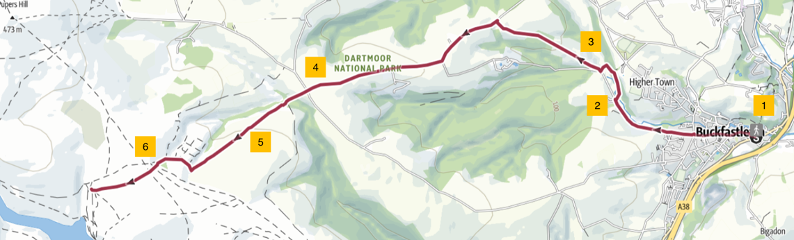
1. The South Hams Way continues along Elliot Plain, a narrow street with old cottages on each side. The river Dean Burn passes underneath; you will cross it again later on our route. Elliot Plain leads into Fore Street where there are refreshment facilities and shops. You will pass The Valiant Soldier museum on your right. At the Globe Inn take the right hand fork into Chapel Street. After about 400yds/metres, at a junction, go straight on into Jordan Street.
2. Proceed out of Buckfastleigh on Merryfield Road for about 0.5 mile/ 0.8km. Turn right at a fingerpost into a field and follow a footpath over a bridge and into woodland. After about 50yds/metres the path bends to the left through the woods and continues uphill to a fork in the path where a marker post directs you left and downhill. Follow the path downhill to a stile. Cross a footbridge, go through a gate and across a field to a gate onto a lane. Turn right and follow a track uphill, past a farm on your right. At a group of barns a little further on, the track (straight on) becomes a footpath.
3. Keep the fence/hedge on your left as the footpath continues through fields. Pass through a wood before reaching another field where you keep the fence/hedge on your right. This leads to Button Farm. Turn right over a stile and then turn left and go through a double gate to walk between the house and barns. Follow the farm access drive to a gate onto a lane. Here turn left and continue steadily uphill on the lane for 1.25 miles/ 2Km to a crossroads.
4. Continue across the road (signposted Plym Ford and Nun’s Cross) and down the stony track to a clapper (slab) bridge crossing the Dean Burn again. Go through a double gate and bear right, past some beautiful old beech trees, to a single gate. Go through the gate and follow a path up a gentle slope through a small wood and into a field. Follow the wide, grassy bridleway which is well marked with blue marker posts.
5. As you climb the hill, with a valley on your right, you get your first real view and taste of Dartmoor; be sure to look behind you at the extensive views in all directions. Ahead of you, in the distance, is a copse at Water Oak Corner - the next destination. After a gate, the path becomes narrow and stony and leads into a wooded gully where you cross a stream. Continue to a gate leading onto the open moor. An old sign on the gate, just readable, tells you that you are now on the Abbots Way.
Note: there are no waymarkers on the open moor.
6. Water Oak Corner. There are no longer any old oaks here. It is the conifers that stand out on our approach, and a mixture of native trees have been planted. There is a choice of paths here but they meet up at the top of the hill as long as you head west. At the top of the hill you get a fine view of moorland all around you and of the Avon Reservoir ahead. Descend into the valley towards Brockhill Stream that flows into the reservoir.
Avon Reservoir to South Brent TEMPORARY ClOSURE part of Section 2: Plan / DCC Notice
Use alternative route: Download Section_2_diversion
1. Do not cross the stream ahead of you but turn left (w3w ringers.barrel.crunching; GR SX 67981 65827) towards Avon Reservoir and pick up a rough footpath running parallel to the stream. Continue along the shore of the reservoir to the dam, which will be on your right. The dam was built in 1957 to supply drinking water to communities in South Devon. Follow the green and stony track downhill to a road (w3w stunts.processes.themes; GR SX 68184 64682). This is the reservoir access road.
2. Bear left and follow the road for about 1.5 miles / 2.4 km. This part of the route is accessible for pushchairs, wheelchairs and mobility scooters. The road takes you down through a steep-sided valley, first to a bridge crossing and then, with the river Avon on your left, past the ruins of Brent Moor House on your right. Continue to Shipley Bridge where there is an information board, car park, toilets, picnic tables and sometimes a mobile cafe. The ruins at Shipley Bridge are a relic of quarrying on the moor for naphtha and china clay.
3. From the car park, turn left onto the lane and over a bridge. After about 100yds/metres, cross a cattle grid and then turn immediately right through a gate onto a signed footpath. Follow the footpath over a stile and through woodland for about 0.5 mile / 0.8 km until you descend a rocky stretch to reach Didworthy.
4. At Didworthy, go straight across a lane and up a slope between houses, keeping Lane Cottage on your left, and take the enclosed bridleway left of Pinewood Lodge gates. Continue along the bridleway, which is enclosed by fences, walls and hedges, for about 0.8 mile / 1.3 km until you reach a gate next to a ford and stone footbridge over a stream. From here follow a wide gravel track to the hamlet of Lutton.
5. Where the track joins a lane, turn right but pause to note the Edwardian letter box (Edward V11) in the gable-end wall ahead of you. After 100yds/metres, turn left past Lutton Cottages 1, 2 & 3 and go through a gate ahead of you and follow the footpath along the left hand edge of a field. Cross a stile and walk across the corner of a field onto a lane. Turn right onto the lane and walk straight on downhill to a T junction. Turn left and follow the road into South Brent. Station Approach is the first turning on your left.
12 September 2025