
Section 8 – East Portlemouth to Torcross
Start: East Portlemouth ferry point. Grid ref: SX 74326 38692 what3words: dugouts.owls.sprinkle
End: Torcross Tank car park. Grid ref: SX 82341 42280 what3words: blanking.outlooks.badge
Distance: 13 miles / 21 kilometres
Ascent / descent: (estimated) 1798ft/548m / 1824ft/556m
Difficulty: Strenuous
OS Map: Explorer OL20
Terrain: Roads, coast path (rocky, narrow & precipitous in places)
Parking: Mill Bay, Gara Rock Hotel, Prawle Point, Start Point, Torcross
Refreshments: East Portlemouth (seasonal), Gara Rock Hotel, Beesands, Torcross
Toilets: Mill Bay, Start Point (seasonal), Beesands, Torcross
Public transport: Devon Public Transport Map
These directions are provided for guidance only. Weather, path closures and other factors may affect the route. Please take extra care when crossing roads and follow The Countryside Code at all times Download Countryside_Code_A5. All maps ©OpenStreetMap
This section is entirely on the South West Coast Path. Follow the acorn signs.
Much of the coastal fringe of South Devon is part of the South Devon National Landscape, formerly South Devon Area of Outstanding Natural Beauty.
East Portlemouth to East Prawle
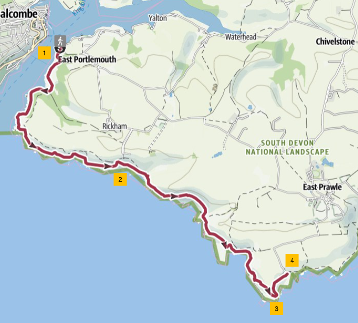
1. From the top of the ferry steps, turn right and walk about 0.5 mile / 0.8 kmon the road to Mill Bay beach. At Mill Bay, take the coast path route to the right and follow it for about 2 miles / 3.2 km to Gara Rock.
2. After 2 miles / 3.2 km, the path splits: left is a path to Gara Rock Hotel and the old lookout. To the right the path descends to Rickham Sand. Unless you decide to divert to the hotel or car park, walk down to Rickham Sand, then continue on the coast path for another 2 miles / 3.2 km, heading towards Prawle Point. This section is rocky, narrow and precipitous. You pass Maceley Cove - accessible by a steep path.
3. Continue along the coast path past the NCI Coastwatch Station at Prawle Point. NCI Prawle Point – Eyes along the Coast If the station is open, the watchkeepers welcome visitors; there is even a small visitor centre to look around.
4. Continue downhill, past the old coastguard cottages on the left, to a gate just below a small National Trust car park. From here it is about 1 mile / 1.6 km inland to East Prawle village where there are a number of facilities: seasonal shop, pub, toilets, parking and accommodation including camping.
East Prawle to Start Point
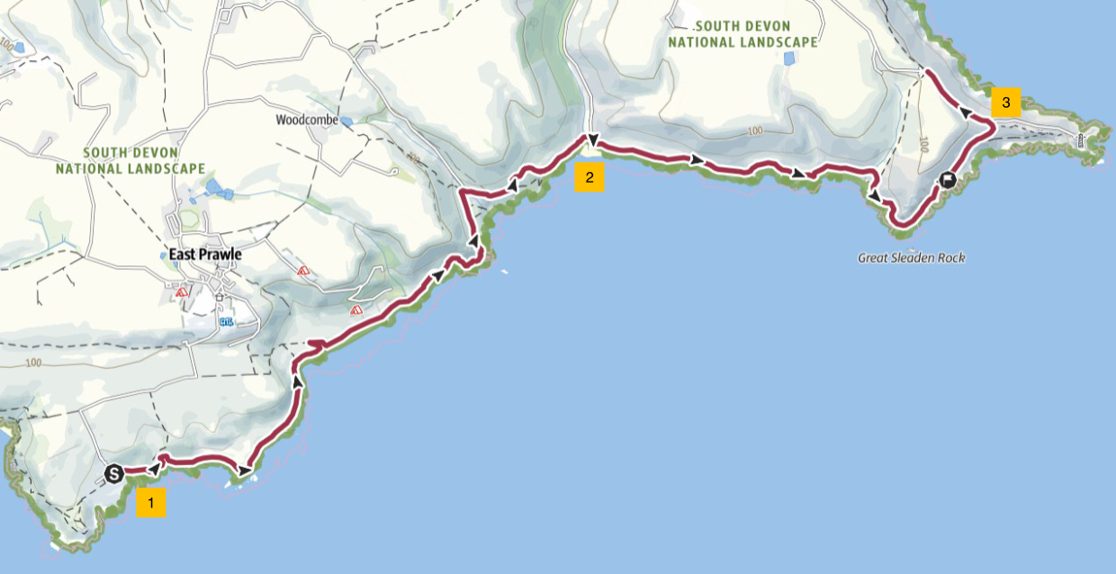
1. From the gate below the National Trust Car Park, follow the coast path eastwards. On the right of the path, just after the start of this section, is a WWII bunker used for detecting low flying aircraft by radar. Continue to Horseley Cove, a rocky beach, and on past Maelcombe House. The path from here is rocky underfoot in places. Continue to Lannacombe and its sandy beach.
2. From Lannacombe, continue along the coast path to Great Mattiscombe Sand, another sandy beach. Keep right to continue along the coast path. On the right, just offshore, are rocks where seals can often be seen resting or swimming in the water close to the shore.
3. When you see the lighthouse ahead, follow the coast path uphill and over the ridge to your left. Now you have fine views of Start Bay as far as Dartmouth. Follow the path to the left and join the lighthouse access road. Follow the road uphill to the Start Point car park. It is worth diverting downhill to visit the lighthouse itself. It is open for tours on certain days. Start Point Lighthouse
Start Point to Torcross

1. Leave Start Point Car Park via the kissing gate onto the coast path heading north. At this point, look along the coastline and you will see the remains of the lost village of Hallsands. Follow the path for about 0.7 mile / 1.1 km to where there is a plaque to the left of the path - 'Hallsands lost to sea January 1917'. This commemorates the destruction of the village of Hallsands by a winter storm but due mainly to the dredging of shingle near the coast which undermined the village. Hallsands
2. Where the path joins a road from the left, in front of Prospect House, turn right along the road. At the end of the road, follow the footpath again. You will descend some steps to join a road. Pass some cottages on your left at North Hallsands. Cross the shingle beach to a gate. Continue up the hill on the coast path towards Beesands.
3. Follow the coast path to Beesands. Walk along the road in front of Beesands seafront cottages. Note the sea defences between the dwellings and the shingle beach; the coast is continuously vulnerable to erosion. Where the access road to Beesands joins from the left, go straight on parallel to the beach. More evidence of coastal erosion can be seen along here, almost cutting off the houses in the distance. Walk towards the houses and then follow the coast path to the left, passing the houses on your right, uphill, around an old quarry (on the right).
4. Descend across an open field, enjoying the views of Torcross village and Slapton Ley. The path zigzags down the hill becoming a tarmac road. On a sharp bend to the right signed ‘Private, Cove House and Downsteps only’, do not turn right but continue a short distance along the road and turn right onto a path. Follow the path to the end and left down steps, through a short tunnel, to Torcross seafront. Walk along the seafront to the far end with weathered houses on your left and more sea defences on your right. Over the sea wall is a shingle beach.
5. At the end of the houses, cross the main road into a car park. Here there is a Sherman Tank recovered from the sea nearby in 1984. This serves as a memorial to the many US servicemen who died during Exercise Tiger, in April 1944, preparing for D-Day. Exercise Tiger Memorial
16 August 2025